As climate change continues to reshape the built environment, integrating flood-risk assessment at...
When a developer, planner, architect or environmental consultant approaches a new site, whether for housing, offices, industrial use or infrastructure, the land beneath their feet hides stories. Groundsure reports help unearth those stories before they become expensive surprises. At CentremapsLive, we’ve long partnered to deliver those reports as a key piece of due diligence. In commercial and residential realms alike, they provide critical insight into contamination, subsidence, flooding, mining, planning histories and climate risks. Without them, you’re navigating with blind spots.
 In the residential sector, Groundsure’s 'Homebuyers' style reports offer a comprehensive environmental screening. They assess contaminated land by compiling record registers of historic industrial sites, permitted waste facilities, known pollution incidents and data from environmental regulators. They flag if a parcel lies within zones of elevated liability under environmental law. Beyond that, they include flood-risk data, from fluvial (river), surface water, groundwater and coastal sources and ground stability checks. They also factor radon, energy infrastructure and planning application histories. In short, the report consolidates dozens of raw datasets into narrative insight and flags risks that a buyer, lender or designer can act on. A housebuyer (or their solicitor) gains clarity about hidden liabilities before committing, reducing post-purchase surprises that might demand costly remediation or structural repair.
In commercial property or land acquisition, the stakes and the scale are of course, higher. Groundsure’s commercial reports expand and deepen the coverage. They scrutinise past industrial use at greater scale, scrutinise waste and pollution licensing records and examine site contamination regimes. They also integrate climate-transition risk metrics, such as energy performance, exposure to changing flood regimes over medium and long term and the implications of green lease obligations or upcoming regulatory thresholds. For office blocks, retail schemes or mixed-use developments, these reports help legal teams advise clients on risks, strategic mitigation and contract clauses. Due to commercial developments often involving multiple buildings or intricate site layouts, the precision of mapping, clarity of disclaimers and spatial accuracy provided in Groundsure reports becomes even more critical.
 Within architectural design, Groundsure reports serve as the vital link between creative vision and the realities of the ground beneath a site. A designer may envision an elegant façade or a highly efficient site layout, but without knowing whether soils are prone to shrink-swell or whether subsidence has been recorded nearby, structural assumptions risk being flawed. The reports flag zones of ground movement, cavity or mining risk and natural instability (e.g. clay expansion/contraction). With this in hand, structural engineers and architects can adjust foundation designs early, specifying deeper footings, piling, ground improvement or drainage control, therefore avoiding mid-project redesign or failure.
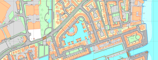
For planners and local authorities, these reports are essential intelligence. When an applicant submits a planning application for residential estates, commercial parks or infrastructure, local planning officers and environmental officers must judge whether proposed land uses are compatible with underlying hazards. Groundsure reports furnish evidence: for example, that a site lies in a coal-mining affected area, or contains contamination hotspots. Planners can precondition remediation or geotechnical surveys as part of the planning consent. They can reject or require design modifications when flood or ground instability risk is too high. In infrastructure projects, the reports act as early warning systems. A planned alignment could pass through zones susceptible to soil failure or sit alongside contaminated land that necessitates targeted construction measures.
An important strength of Groundsure reporting is data provenance and quality. Groundsure draws on key data sources, including the British Geological Survey (BGS) for geological, mineral and soil chemistry information and the Coal Authority for mining-related risk data. Their flood data often comes from specialised flood modelling providers, giving granularity across multiple hazard types. The raw datasets are often extensive and complex, the true value of the report comes not just from compiling the data but from expert interpretation, highlighting probabilities and recommended actions. This enables non-specialist users to apply the insights effectively rather than being overwhelmed by raw tables.
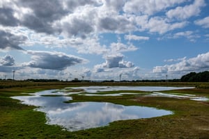
One of the most forward-looking aspects of these reports is inclusion of future climate risk modules (often branded under names like ClimateIndex™). These overlay projected risks over time, how flood extents shift, how subsidence potential may vary under changing rainfall regimes or soil moisture and present transition risks tied to energy efficiency, changing regulation or insurance exposure. For developers and developers’ lenders, understanding not just current risk but how that risk might evolve is becoming non-optional under due diligence regimes, legal duty of care or lender expectations.
 Case studies within the industry show the payoff. A development team expanding a business park discovered, through a Groundsure commercial search, historic landfill activity under one parcel. They delayed structural works to commission targeted borehole testing and soil remediation, reducing the possibility of foundation failures or liability. In another residential scheme, a Homebuyers-level report signalled subsidence risk zones near tree root systems, the developer redesigned foundations in those zones from standard strip footings to piled foundations in advance, avoiding crack repairs after sale.
Without such reports, hidden risks often surface mid-build, unexpected contamination, failed footings, unanticipated pile costs, insurance rejections or regulatory objections. Those surprises can collapse budgets and reputations. By contrast, with robust reports, project teams gain clarity, set reliable contingencies, influence contract terms and inform stakeholders early.
To deploy Groundsure reports effectively, integration into workflow is key. When a site is first considered, trigger the report purchase early, even as a desktop step. Use it to assess whether the site is viable or whether further intrusive ground investigation is justified. Share summary insights with architects, structural and civil engineers, planning consultants and environmental advisors. Use flagged risk zones to guide sampling strategy rather than random testing. Finally, let the report narrative inform tender briefs, construction method statements, foundation choices and design contingency.
In summary, Groundsure reports are indispensable in both residential and commercial development because they translate subterranean uncertainty into actionable intelligence. They protect financial viability, improve design resilience, streamline planning dialogue and reduce surprise-costs. For CentremapsLive clients drawing from utility, mapping, planning and site data streams, the addition of a trusted Groundsure environmental/geotechnical report completes the picture.
CentremapsLive makes accessing and integrating Groundsure reports effortless, helping to streamline your project workflow. Simply define your site area within the platform and add your chosen Groundsure report directly to your order. This enables you to combine mapping, utility and environmental data in one easily accessible place, making due diligence, planning and design decisions faster, clearer and far more manageable.