In the world of planning, architecture and engineering, access to accurate and comprehensive...
In the world of remote sensing and geospatial data collection, two technologies have emerged as game-changers: LiDAR and Aerial Imagery. These methods provide invaluable insights into our environment, aiding various industries such as agriculture, urban planning, forestry and more. In this article, we will delve into the intricacies of LiDAR vs. Aerial Imagery, comparing their strengths, weaknesses and applications.

What is LiDAR?
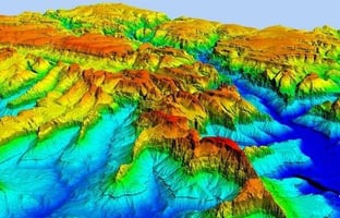
LiDAR, short for Light Detection and Ranging, is a remote sensing technology that uses laser pulses to measure distances and create highly accurate three-dimensional models of the Earth’s surface. Here are the key points:
-
Precision: When pinpoint accuracy is paramount, LiDAR takes the lead. Its laser-based technology ensures precision in elevation measurements. LiDAR can accurately measure the height of buildings, tree canopies and even the smallest changes in the Earth’s surface. This makes it indispensable for applications like flood modelling, urban planning and archaeology.
-
Limitations: LiDAR data collection can be expensive due to specialised equipment and aircraft. Additionally, interpreting LiDAR point clouds requires expertise.
What is Aerial Imagery?
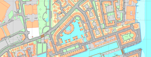
Aerial Imagery involves capturing images of the Earth’s surface from an elevated position, typically using aircraft or drones equipped with cameras. Here’s what you need to know:
-
Visual Information: While not as precise in elevation data, Aerial Imagery excels in capturing visual information. It provides high-resolution images that are invaluable for applications such as land-use planning, agriculture and disaster management. The ability to see the real world from above can offer insights that LiDAR alone cannot provide.
-
Cost-Effectiveness: Aerial Photography is more cost-effective than LiDAR. It allows for broader coverage and can be scheduled more reliably.
-
Weather Considerations: Aerial Photography, however, is more affected by adverse weather conditions (rain, fog, or cloud cover) compared to LiDAR, which relies on laser pulses.
Choosing Between LiDAR and Aerial Imagery
The decision between LiDAR and Aerial Imagery depends on project needs and budget constraints. Here are the key considerations:
-
Accuracy: If precision is critical (e.g., for infrastructure design or archaeological surveys), LiDAR is the go-to choice.
-
Visual Insights: For visual interpretation and broader coverage, Aerial Imagery shines. It’s excellent for land-use planning, environmental monitoring, and assessing real-world conditions.
-
Budget: LiDAR can be more expensive, while Aerial Imagery offers a cost-effective alternative.
-
Weather Dependence: Consider the weather conditions in your study area. LiDAR is less affected by adverse weather.
Conclusion
Both LiDAR and Aerial Imagery have their unique capabilities. Choosing the right data source requires assessing project requirements, accuracy needs, and available resources. Whether you’re mapping forests, planning urban infrastructure or studying historical sites, understanding the strengths and limitations of each technology will guide your decision.
In the world of geospatial technology, LiDAR and Aerial Imagery stand as formidable options, each with its unique capabilities. Choosing between the two requires a careful assessment of project needs and budget constraints.
If you have any other questions, feel free to ask!